
Category:Geological diagrams in English
Subcategories
This category has the following 6 subcategories, out of 6 total.
Q
Pages in category "Geological diagrams in English"
This category contains only the following page.
Media in category "Geological diagrams in English"
The following 92 files are in this category, out of 92 total.
-
 1893 chromolithograph - Geological Chart.jpg 2,685 × 1,800; 1.1 MB
-
 AFV Hypotheses.png 3,333 × 1,667; 400 KB
-
 AFV Hypothses-2.png 4,167 × 1,667; 483 KB
-
 AncientLakeAtna.gif 3,108 × 2,384; 4.49 MB
-
 Anticline-Syncline-s-ink-FabioCrameri.png 2,616 × 949; 1.71 MB
-
 Basin Type Map.jpg 2,223 × 2,031; 1,019 KB
-
 Bif in time.jpg 792 × 612; 37 KB
-
 Biogenic-varves.svg 512 × 313; 27 KB
-
 Biozones.jpg 2,429 × 1,831; 325 KB
-
 Bouma Sequence.jpg 1,630 × 1,767; 314 KB
-
 Bulletin 426 Fig 8 Donald quarry pegmatites.jpg 887 × 1,030; 252 KB
-
 CalabrianArc-GeotectonicSection.jpg 5,974 × 1,629; 3.61 MB
-

-
 Chronosomes.png 1,264 × 893; 154 KB
-
 Chronosomes.svg 842 × 595; 31 KB
-
 Circum-Superior Belt age map.jpg 550 × 288; 40 KB
-
 Compositional and Textural Maturity.jpg 4,613 × 3,853; 2.28 MB
-
 Discordances successives Jurassique Préalpes.jpg 2,304 × 1,695; 563 KB
-
 Dome and Keel Cross Section.pdf 1,133 × 752; 916 KB
-
 Downwelling.gif 995 × 790; 90 KB
-
 Dune en.svg 500 × 400; 28 KB
-
 Earth-crust-cutaway-english.svg 995 × 684; 117 KB
-
 Effective porosity 1.jpg 856 × 573; 97 KB
-
 Effective porosity 2.png 985 × 558; 60 KB
-
 Faults and folds.jpg 360 × 458; 31 KB
-
 Fig 1 Emad final thin boundary2.jpg 1,980 × 1,695; 1,002 KB
-
 Flank & hinge.PNG 1,019 × 823; 359 KB
-
-
 Flux of crustal material in the mantle.jpg 1,942 × 1,112; 654 KB
-
 Formation of Contractional Mountain.png 1,024 × 768; 125 KB
-
 Formation of cross-bedding.jpg 688 × 215; 47 KB
-
 Formation of cross-stratification.png 618 × 380; 26 KB
-
 Geologic Principles.jpg 267 × 600; 33 KB
-
 Geological time spiral.png 2,424 × 2,145; 1.86 MB
-
 Geospeedometry diffusion illustration.pdf 2,000 × 1,125; 495 KB
-
 Glacial ice formation LMB.png 238 × 265; 12 KB
-
 Glacial indicators.jpg 2,563 × 2,110; 1.06 MB
-
 Glacial lakes.jpg 750 × 545; 114 KB
-
 GreatIndianBasinModel.jpg 2,492 × 2,407; 302 KB
-
 Heat flow of the inner earth.jpg 1,500 × 1,125; 340 KB
-
 Heat-pipe Model.png 1,512 × 581; 123 KB
-
 Heterogeneous microbial reaction.jpg 906 × 523; 777 KB
-
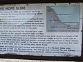 HopeSlideDiagram.jpg 2,592 × 1,944; 583 KB
-
 Ice flow controls.jpg 229 × 600; 42 KB
-
 Ice-floe params hg.png 2,800 × 1,373; 115 KB
-
 Igneous Rock ID.jpg 4,146 × 2,914; 1.34 MB
-
 Internal Structure of Marine Terrace.jpg 1,014 × 601; 143 KB
-
 IntraoceanicIslandModel.jpg 2,468 × 2,113; 493 KB
-
 Io thrust.png 2,148 × 1,519; 318 KB
-
 Isua evolutionry.png 1,019 × 1,124; 369 KB
-
 Law of superposition.png 272 × 158; 2 KB
-
 Lithosphere of Earth - Idealized Cross-section.jpg 2,128 × 822; 234 KB
-
 Lithostratigraphy and Sequence Stratigraphy.jpg 5,553 × 4,258; 1.95 MB
-
.png/120px-Lituya_Bay_megatsunami_diagram_(English).png) Lituya Bay megatsunami diagram (English).png 1,028 × 609; 212 KB
Lituya Bay megatsunami diagram (English).png 1,028 × 609; 212 KB
-
 Magma Differentiation showing minerals settling.png 875 × 683; 88 KB
-
 Magma Differentiation.jpg 1,048 × 883; 99 KB
-
 Magma Differentiation.png 840 × 620; 75 KB
-
 Map View of Pull Apart Basin.jpg 1,153 × 1,408; 370 KB
-
 Measures of Sea Level.jpg 4,219 × 2,133; 472 KB
-
 Metamorphic facies EN.svg 744 × 602; 32 KB
-
 Metamorphic Facies Series.png 741 × 600; 71 KB
-
 MVT Deposits.png 974 × 365; 65 KB
-
 NewScheme-GD-tech.png 2,283 × 3,538; 370 KB
-
 Orogen Types - Diagram.jpg 1,733 × 1,332; 344 KB
-
 Outgassing.jpg 1,688 × 2,249; 694 KB
-
 Oxygen vs time.png 1,022 × 569; 45 KB
-
 Permian North China Craton.png 1,184 × 538; 82 KB
-
 Phase transformations in the transition zone 2.0.jpg 585 × 626; 199 KB
-
 Phase transformations in the transition zone 2.0.svg 527 × 588; 34 KB
-
 Phase transformations in the transition zone.jpg 1,024 × 768; 187 KB
-
 Plate Boundaries Inforgraphic.jpg 1,897 × 1,713; 232 KB
-
 Rift Arms.jpg 2,037 × 1,035; 268 KB
-
 Roche moutonnée eng text.png 543 × 371; 93 KB
-
 Rock Cycle.jpg 4,968 × 1,743; 360 KB
-
 Sequence Architecture.jpg 5,550 × 3,788; 1.6 MB
-
 Sequence Stratigraphic Nomenclature.jpg 3,151 × 2,455; 1.63 MB
-
 Sill-en.svg 702 × 333; 7 KB
-
 Six evolutionary temperature simulations.png 2,224 × 1,668; 223 KB
-
 Stratigraphy NE pook.jpg 429 × 588; 113 KB
-
 Subsidence History.jpg 3,152 × 2,050; 1,022 KB
-
 Tectonic evolution of Earth.jpg 1,500 × 1,125; 184 KB
-
 Tectonics and Relative Sea Level.jpg 5,500 × 2,660; 618 KB
-
 Tension, compression, shear.png 350 × 205; 4 KB
-
 The layers of the Earth model.jpg 2,560 × 1,920; 543 KB
-
 Tidal Rhythmites.jpg 2,822 × 2,022; 3.14 MB
-
 Transgressions and Regression.jpg 5,220 × 4,370; 1.16 MB
-
 Type of aquifers.png 546 × 354; 90 KB
-
 Unconformities Diagram.jpg 5,310 × 3,626; 1.82 MB
-
 Unconformities flow chart.svg 2,535 × 2,241; 518 KB
-
 Volcanic Resurfacing.png 1,579 × 696; 129 KB
-
 Wilson-cycle hg.svg 1,112 × 607; 22 KB
-
 Yellowstone Caldera.svg 560 × 289; 61 KB


.png)


